Blog
5 Benefits of Using Large Format Printers to Create GIS Topographic Map Documents
Technical Printing
|19 Jul 2023
GIS topographic map documents serve an important purpose in various fields, providing valuable insights into the terrain and supporting informed decision-making by topographers. These maps fuel the industry-wide requirement for topographic data to be transformed into high-quality prints because they make it much easier to effectively interpret this data to achieve results.
In this context, large format printers offer a range of advantages. With their ability to produce high-resolution output, accommodate different size requests, and render data with precision, large format printers are a top choice for creating any GIS topographic map.
Moreover, large format printers excel in replicating data on various paper media, thereby offering multiple visual representations of topographic data and underscoring the value of these printers in enhancing the quality and effectiveness of topographic mapping endeavours.
What Are Topographic Maps?
Topographic maps in GIS represent elevation over a geographic area. These maps use elevation contour lines or shading to display precise elevation differences, along with other surface features like roads and settlements, lakes and rivers, mountains, and coastlines. Topographic maps are the result of detailed surveys and satellite images. They often help with large-scale projects like land development and ecological conservation efforts.
The Connection Between GIS and Topographic Maps
The Importance of Accurate Representations in Topographic Map Data
Understanding the Role of Large Format Printers for GIS Topographic Map Printing
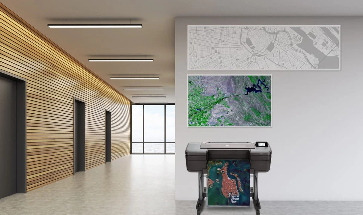
GIS topographic map files are not just digital features. They are very often printed to serve as guides and visual aids for the operations of other businesses. Large format printers make it possible to prepare large-scale maps for industrial or ecological use. Maps created using topographic information often benefit from having a larger version of the map mounted on a wall or set on a tabletop. The larger size then makes it possible to see refined detail in any given space, even on a large format printer.
The Benefits of Using Large Format Printers for GIS Topographic Maps

In fact, large format printers have a wide range of tools that can help a GIS office print high-quality larger maps. These include:
1. High-Resolution Output
2. Increased Map Size Options
3. Detailed Rendering of Elevation Data
4. Precise Colour Representation
5. Durability and Longevity
Best Practices for Creating GIS Topographic Maps With Large Format Printers
When creating your GIS topographic map files and documents, large format printers are your best option. But the default settings might not be what you're looking for. This means that, by understanding large format printers, you can create higher-quality maps with more detail and durability per inch.
Optimising Your Topographic Maps With Large Format Printer Settings
Resolution Settings
Colour Calibration
Choice of Paper Media
Techniques to Enhance Map Legibility and Visual Appeal
Labelling
Symbolisation
Scale Representation
Reach Out to HP to Receive GIS Map Printing Solutions
Printing topographic maps is an important part of GIS topographic developments. HP large format printers provide the precision and adaptive features you need to print high-quality topographic maps. Contact us for GIS map printing support at any time.
Download our eBook now and discover how innovation is streamlining workflows, producing prints of unmatched quality and increasing IT efficiency like never before.
<iframe src="undefined"></iframe>You Might Also Like

Everything you need to know about choosing a plotter printer

Best Compact Large Format Printers for Small Business Offices

How to Choose the Best Industrial Plotter for Your AEC Business

Best Budget Plotter Printers for Small Business Print Shops

Which to Pick: Plotter or Laser Printers for Technical Drawings

Main Trends in the Technical Printing Sector in 2024

Top 7 Professional Large Format Printers to Buy in 2024

Get Photo-Quality Prints With a Large-Scale Colour Plotter Printer

The Key Benefits of Large Format Printing for Spatial Data in GIS

Considerations to Help You Get the Right Digital Blueprint Printing Machine for Your AEC Business

10 Creative Uses for Large Format Poster Printers

5 Ways a Large Format Printer Can Streamline Your Business Workflow

Plotters and Their Types: Uncovering Plotter Cost Considerations

Everything You Need to Know About Plotters and Their Applications

Optimising Printer and Plotter Capabilities for Small Businesses

Uses of Plotters for Small Businesses: Affordable Solutions for Big Impact

How to Print a Poster With HP's DesignJet T850 Printer

5 Factors to Consider When Buying an Inkjet Plotter

The Best Plotter Printers for Creating GIS Map Systems

Latest Innovations in Printing Technology: Top 5 Uses of Large Format Printers in the Construction Sector
Select Your Country/Region and Language
Close Country/Region Selector Dialog
Europe, Middle East and Africa
- Africa
- Afrique
- België
- Belgique
- Česká republika
- Danmark
- Deutschland
- Eesti
- España
- France
- Hrvatska
- Ireland
- Italia
- Latvija
- Lietuva
- Magyarország
- Middle East
- Nederland
- Nigeria
- Norge
- Österreich
- Polska
- Portugal
- România
- Saudi Arabia
- Slovenija
- Slovensko
- South Africa
- Suisse
- Suomi
- Sverige
- Switzerland
- Türkiye
- United Kingdom
- Ελλάδα
- България
- Казахстан
- Србија
- Україна
- ישראל
- الشرق الأوسط
- المملكة العربية السعودية
Country/Region :
Close Country/Region Selector
SelectedAustralia
popUpSRBeginingLabelString
HP Worldwide
Select Your Country/Region and Language
Click or use the tab key to select your country
Close Country/Region Selector Dialog
- Africa
- Afrique
- América Central
- Argentina
- Asia Pacific
- Australia
- Bangladesh
- België
- Belgique
- Bolivia
- Brasil
- Canada
- Canada - Français
- Caribbean
- Česká republika
- Chile
- Colombia
- Danmark
- Deutschland
- Ecuador
- Eesti
- España
- France
- Hong Kong SAR
- Hrvatska
- India
- Indonesia
- Ireland
- Italia
- Latvija
- Lietuva
- Magyarország
- Malaysia
- México
- Middle East
- Nederland
- New Zealand
- Nigeria
- Norge
- Österreich
- Pakistan
- Paraguay
- Perú
- Philippines
- Polska
- Portugal
- Puerto Rico
- România
- Saudi Arabia
- Singapore
- Slovenija
- Slovensko
- South Africa
- Sri Lanka
- Suisse
- Suomi
- Sverige
- Switzerland
- Türkiye
- United Kingdom
- United States
- Uruguay
- Venezuela
- Việt Nam
- Ελλάδα
- България
- Казахстан
- Србија
- Україна
- ישראל
- الشرق الأوسط
- المملكة العربية السعودية
- ไทย
- 中华人民共和国
- 臺灣 地區
- 日本
- 香港特別行政區
- 한국
- Recalls |
- Product recycling |
- Accessibility |
- Modern Slavery Act Statement |
- Privacy |
- Terms of use |
- Use of cookies |
- Australia packaging covenant |
©2025 HP Development Company, L.P. The information contained herein is subject to change without notice.